- Home
- San Francisco Attractions
- Golden Gate Bridge
The Golden Gate Bridge

Here are some local tips on visiting the Golden Gate Bridge: how to get there, where to park, driving, walking or biking across it, and the best tours of the bridge.
The Golden Gate Bridge is the icon for San Francisco, and was voted the #1 best thing to see in San Francisco (U.S. News and World Report, 2017) ... it would be pretty hard not to see it if you're in the City!
The Golden Gate Bridge is gorgeous and the setting is breathtaking. But seeing it in person is even more beautiful than the photos.
 View from the Marin Headlands
Golden Gate Bridge Facts
- Total length: 1.7 miles (2.8 km)
- Main span length (suspended part): 4,200 ft (1,300 m)
- Width: 90 ft (27 m)
- Tower height: 754 ft above water; 500 ft above roadway
- Roadway 220 ft (67 m) above the water
- Built from 1933-1937
- Named for the Golden Gate Strait
- Tallest bridge in the U.S.
- Longest suspension bridge in the world until 1964
- Official color: International Orange
- 6 lanes of traffic
- 112,000 cars cross the bridge every day
 Golden Gate Bridge Dimensions
Building the Bridge
The construction of the Golden Gate Bridge was so difficult, it has been officially named one of the seven engineering marvels of the modern world.
Wind, currents, fog, sheer cliffs, and politics fought to prevent this bridge from taking shape, but when it was done in 1937, it was not only the most beautiful bridge, it was also the longest and tallest suspension bridge in the world.
It held that title until 1964, and was the second longest suspension bridge in the world until 1981.
Read more on the history of the Golden Gate Bridge, and why it almost went the way of its sister bridge, Galloping Gertie, up north (into the water!)
Is it ready for The Big One?
The 1989 earthquake on the northern San Andreas fault (7.1 Richter scale) was just a tiny taste of what's coming with the Big One, as local's call it: the rerun of the 1906 San Francisco quake, an 8.0 level shaking.
Luckily, the epicenter of the 1989 earthquake was 56 miles south of San Francisco, in the Santa Cruz mountains. Engineers believe a San Andreas rupture of a 7 level closer to the city could have caused severe damage, but fortunately the Golden Gate was unscathed (unlike the Bay Bridge).
Studies of the bridge after this earthquake led scientists to believe an 8.0 level earthquake could cause the approaches to the bridge to collapse. So a plan to retrofit the bridge was created.
Earthquakes of this magnitude (8.0) have hit this section of the San Andreas fault on average every 100 years (and it's been 119 since the last one, but who's counting). Retrofitting began after the 1989 quake, and is still ongoing.
Sections have been reinforced with steel plates, and pylons have been anchored to the bedrock. Also, joints have been installed at certain points to release energy and allow for expansion.
The second phase of the retrofit was completed in 2008 and engineers from the Golden Gate Bridge, Highway and Transportation District said the bridge could now weather an earthquake of a low 8 on the Richter scale.
The third phase of construction is ongoing. The last part of the retrofitting project involves strengthening the main suspension system of the bridge. This project is scheduled to began in 2025 and should finish in 2029.
The good news is that engineers don't believe the bridge in its present state would fall down in the Big One.
The overall plan is designed to make it sail through the Big One with only minor damage, if any.
For more details, see article and video at B1M construction website.
Beautiful, But Deadly
In part due to its fame and striking beauty, the Golden Gate Bridge has sadly been one of the most popular suicide spots in the world. On average, someone jumps about every two weeks.
In all, over 2500 people have jumped from the bridge; 98% have died.
The bridge is patrolled by volunteers who are trained to talk to would-be jumpers; they've saved hundreds of lives. You'll also see telephones on the bridge where people can talk to someone if they're feeling suicidal.
Suicide barrier - finally complete
After years of talk and debate, the city decided to build a metal net under the entire bridge. And it was finally completed in January 1, 2024.
It won't stop someone who's really determined, but it will give them time to rethink. A number of the survivors have said they regretted their decision the moment they were in the air.
The net was installed 20 feet below the roadway and sticks out about 20 feet on each side.
They have been rigging the net during the night, Mondays through Fridays, 9 pm to 5 am, to minimize traffic bottlenecks, since they have to close one lane on each side to do the work.
It's been a very slow process, given the steady loss of life every year. Installation of the net finally started in August of 2018, and was supposed to have been completed in 2021. But there have been a series of delays, the most recent coming from a legal dispute between the contractor and the Transportation District, representing the city.
See suicide deterrent net for details.
Update: it seems to be working. A report done in July of 2024 stated that there has been a sharp drop in suicide deaths on the bridge (3 deaths vs. 15-20 typically). There has also been a huge drop in suicide attempts (56 vs. 100), so maybe the existence of the net has also discouraged would-be jumpers.
Even jumping into the net can be painful and cause injury.
The Golden Gate Bridge Color
The color was chosen sort of by accident. When the bridge was being built, the metal structure was coated with a reddish primer.
One of the architects noticed that the color went beautifully with the blue water and golden-brown hills, and came up with the current color. Plus, it stands out in the fog. Thank you, Irving F. Morrow!
Tip: if you want to paint something the same color as the Golden Gate Bridge, it must be the right shade of International Orange; there are several versions, used for different purposes.
The official formula for the Golden Gate Bridge color is Cyan 0%, Magenta 69%, Yellow 100%, Black 6%. The correct hex triplet is F04A00.
Painting the bridge: there is an urban myth that the bridge is continuously painted from one end to the other, then over again. Not so. There is a staff of 34 full-time painters that work just on the spots that need touching up. And they are currently using Sherwin Williams paint.
Visiting the Golden Gate Bridge
Over 10 million people visit the Golden Gate Bridge every year. It has to be one of the world's most beautiful sights; even for locals, the sight of it never gets old.
The complementary colors of the red-orange bridge and the brown, rocky hills, the blue water and sky, and the graceful sweep across the straight is spectacular.
The San Francisco Side of the Bridge
What's on the San Francisco side of the bridge?
- The Welcome Center
- Roundhouse Restaurant
- Great views!
- Bike paths and walkways
- Fort Point
- The Presidio
- Parking lots
- Bus stops

Note: I may earn a small commission if you make a purchase through some of the links on this page, at no extra cost to you. This helps me provide all the free information I post on this website. Thank you for your support!
The Welcome Center
The Welcome Center is open, as well as the parking lot, along with the other parking lots in the area.
The current Welcome Center is relatively new and combines a gift shop with some educational displays about the bridge. Good place to pick up maps. Worth a brief visit. Open daily, 9 to 6.
If you're in the mood for souvenirs, like Golden Gate Bridge rivets, books, t-shirts or fog globes, this is the spot.
 Welcome Center
It's located just off the parking lot where the tour buses and the #28 city bus stop.
At the Welcome Center Plaza, they have some interesting displays about the history and construction of the bridge, with more exhibits just on the other side of the bridge (via the underpass).
The Roundhouse Cafe
This round building above the Welcome Center was built at the same time as the bridge, and in the same Art Deco, 1930's style.
 Roundhouse Cafe
The Roundhouse Cafe is a good place to stop for lunch or a snack while visiting the bridge. They serve hot dogs, soup, salads and sandwiches, and the views are amazing.
I had the crab bisque in a sourdough bread bowl when I was there: very tasty, and a bit spicy.
Open 8:30 to 4.
There's also a snack bar, the Bridge Cafe, just below it, that looks like it was built at the same time, in the same style, but it was actually built in 2012 to match the other buildings. They sell mainly packaged snacks and drinks.
Getting to the Bridge
The Golden Gate Bridge is very easy to get to. Driving is easy because there are number of parking lots close by, and city buses make frequent stops at the Welcome Center, near the southern end of the bridge.
Plus, the Hop On Hop Off buses stop near the Welcome Center, and there are good bike paths to the bridge from Fisherman's Wharf, where you can rent bikes.
Driving to the bridge...
Unlike driving and trying to park at many of San Francisco's favorite attractions, driving to the Golden Gate Bridge is no reason for a nervous breakdown! The surprise is that it's also easy and cheap to park there.
If you are heading for the bridge on the Presidio Parkway (also Highway 101), take the last SF exit before the bridge. You'll need to be in the far right lane, and a sign warns you it is the last SF exit. From there, you can access the parking areas on either side of the bridge.
You can also approach the bridge from either the east or west sides on Lincoln Boulevard. You can drive under the bridge near the Welcome Center parking lot, and Lincoln Blvd. also goes under the Presidio Parkway.

Tips for Parking at the Bridge
I've scouted all the lots on both sides of the bridge, and marked them on the maps.
 Map of the Nine Lots in the SF Side
For a complete rundown on all the lots on the map above, and advice on the best places to park, see my page on Golden Gate Bridge parking.
I've also included details about parking on the Marin side of the Golden Gate, plus a map on how to find those as well.
Ride a bike to the bridge...
There are a number of excellent bike paths in the area near the bridge on the SF side; this is a popular biking spot for both locals and visitors.
Bike rentals: There are no bike rental offices near the bridge, but you can rent bikes at several places near Fisherman's Wharf and on Lombard Street en route to the bridge. From there, it's a relatively easy, and very scenic, ride to the bridge. Fun for kids, too, and mostly flat.
See my tips on where to rent the bikes, plus information on biking across the bridge and taking the ferry back. There are some good deals available for both renting bikes and taking bike tours over the bridge.
Getting to the Bridge by Bus (SF side)...
It's easy to get to the Golden Gate Bridge by bus from many points in San Francisco; here are some options:
From Fishermans's Wharf. The #28 - 19th Avenue - Muni Bus stops right next to the Welcome Center, at the SF end of the bridge. You can catch it on Van Ness Avenue, between North Point and Bay, at the western end of the Fisherman's Wharf area, a couple of blocks west of Aquatic Park. You can also catch it in Golden Gate Park. See #28 route.
 Bus #28 at the Welcome Center (plus Hop On Hop Off bus)
From Downtown SF. The #130 Golden Gate Transit bus runs daily, about every hour, from the Transbay Transit Center at 425 Mission Street, stopping at Civic Center (McAllister & Polk, by City Hall). Get off at the Toll Plaza just before the bridge (it also crosses the bridge and goes into Sausalito). See the #130 route.
From Union Square. The #76X Marin Headlands Express bus (currently suspended since Covid) also stops at the Toll Plaza. Catch it at Post and Powell streets, at Union Square Note: weekends only.
You can also walk down Powell Street, past Market, to Mission Street and catch the #130 Golden Gate Transit bus there.
 Bus Stop at the Toll Plaza.
Buses #130 and #76X stop here.
Bus Stop at the Toll Plaza.
Buses #130 and #76X stop here.PresidiGo Shuttle
There's a free shuttle that used to run from downtown out to the Golden Gate Bridge, with one change at the Presidio. Unfortunately, due to Covid cut backs, the shuttle only runs to the Presidio and you would need to get off at the entrance to the Presidio and walk 3 blocks north to catch the #28 Muni bus to the Welcome Center at the bridge. Not nearly as convenient as before.
The PresidiGo buses run all day, seven days a week. See PresidiGo for the routes and schedules.
You can catch the Downtown PresidiGo shuttle near the Embarcadero BART station (Drumm Street at California). Get off at Lombard and Lyons streets at the Presidio entrance and walk north (right) up Lyon Street 3 blocks to Francisco Street where the #28 bus stops.
Hop On Hop Off Buses
All the double-decker, Hop On Hop Off buses stop at the Welcome Center parking lot right next to the bridge.
The Hop On Hop Off buses also have a loop that takes you across the bridge, and down into the town of Sausalito. The Sausalito loop is now included in all the City Sightseeing 2-day and 1-day-plus bus passes.
You can get off the main city loop and pick up the Sausalito loop at the same bus stop, in the parking lot of the Welcome Center for the bridge. See map above.
 Hop On Hop Off Bus Heading for the Welcome Center
The Sausalito loop buses also stop at Vista Point, one the best places to view the bridge at the northern end.
See Hop On Hop Off bus tours for more info and booking.
Tip: if you do the Sausalito loop of the Hop On Hop Off bus tour, you can get off at the Vista Point at the north end of the bridge, cross under the bridge and walk up to a spectacular view spot in the Marin Headlands (see map of pathway below).
Highly recommended! See more on views from the Marin Headlands.
Bus Stops Near the Bridge

Buses #130 stops at the Toll Plaza.
Crossing the Golden Gate Bridge...
It's free to walk or bike across the Golden Gate Bridge. The pedestrian walkway is the east sidewalk that runs along the east (bay) side of the bridge. Bikes ride on either side, according to the daily schedule.
Drivers pay a toll ($10.75 as of Jan 1, 2026) but only coming into San Francisco. More on how to pay the toll below.
 Approach to East and West Sidewalks on the Bridge
Walking the Golden Gate Bridge
This is a great way to experience the bridge. Not only can you see the towers up close, there are super views of the city, Alcatraz and the bay. And it's free!
Pedestrians are only allowed on the east sidewalk (bay side) of the bridge, but it has the best bay and city views.
Walkers share the east sidewalk with bicycles on weekdays until 3:30 pm. Weekends and holidays, it's pedestrian only.
 East Sidewalk
Open to pedestrians:
Pacific Standard Time (winter): 5 am - 6:30 pm
Daylight Savings time (summer): 5 am - 9 pm
How long does it take to walk across the Golden Gate Bridge? The bridge is 1.7 miles across, so it's about a 35 minute walk each way.
If you do the Hop On Hop Off bus tour, you can walk one way and catch the bus at the other end (Vista Point) to avoid the return walk.
The other side at Vista Point has bathrooms, but not much else (other than another great view).
When is the best time to walk across the bridge? Pros and cons...
Mornings: less crowded, but you are looking east, into the sun (not the best from a photographer's viewpoint). And on weekdays, you'll be sharing the sidewalk with bicycles until 3:30 pm.
Late afternoon: more people are out there, but light is gorgeous (when it's not foggy) and the colors are glowing. Plus, no bicycles are allowed on the east sidewalk after 3:30 pm.
Best time (in my opinion): weekdays after 3:30 pm. Beautiful light and all the bicycles are on the west side of the bridge. Second best time? Weekends in the afternoon; the cyclists are on the west side all day, but there are more walkers on the bridge, too.
Tip for walking the bridge: dress warmly, in layers! San Francisco is not a very warm place, especially in summer. Even when the sun is shining, it can be rather cool. And it's colder on the bridge because cool winds are usually blowing in through the gap from the chilly ocean. The bridge is very windy.
Also, the fog comes and goes suddenly and unpredictably; the fog will drop the temperature abruptly. More on San Francisco weather.
Bike the Golden Gate Bridge
This is one of the most popular ways of experiencing the Golden Gate Bridge. You can ride a bike over and back, or take the popular bike ride over the bridge and down into the seaside town of Sausalito, returning to the city by ferry.
 Biking the East Sidewalk
Almost everyone going on to Sausalito (far below) opts to ride the ferry back to San Francisco; that avoids the tough ride back uphill and puts you on a ferry ride with great views of the city and Alcatraz (rated #2 best ferry trip in the world by the Society of American Travel Writers).
There are two ways to do it:
- Ride over on your own
- Take a guided bike tour
Insider tips on biking the bridge...
I've put together some helpful information on both renting bikes and taking bike tours over the bridge. See what the trip is like, what to do in Sausalito, tips on taking the ferry, and how to get some good deals on both bike rentals and tours, at biking the Golden Gate Bridge.
The do-it-yourself bike tour
You can ride your own bike over, or rent a bike and follow the map provided.
It's a pretty easy route to follow, though there are some hills to climb (see my photos, maps and description of our ride over the bridge and into Sausalito at biking the bridge).
If you don't want to do the ride down to Sausalito, you can just turn around and ride back across the bridge.
Guided bike tour over the bridge
There are a number of bike tours available where a guide takes you on a ride to the bridge, usually from Fisherman's Wharf, across it, and then down into the town of Sausalito, where you have time to explore before you take the ferry back to the city.
See my suggestions for taking the bike tours.
More Tours of the Golden Gate Bridge
In addition to the above-mentioned bike tours, there's a good walking tour of the bridge, and bus tours that cross the bridge.
Walking tour of the bridge
San Francisco City Guides: this is a free tour given twice a week, year round, by a non-profit organization that does lots of SF tours. Their guides are all volunteers, but very professional and knowledgable.
I've been on several of their tours and really enjoyed them. No reservations, just show up at the appointed time and place. See Golden Gate Bridge tour.
Golden Gate Bridge Bus Tours
Hop On Hop Off Bus Tour
The Hop On Hop Off buses cross the bridge on their Sausalito loop. They stop at both ends of the bridge: the Welcome Center parking lot and the Vista Point parking lot.
You can admire some of the best bridge views at both ends of the bridge, plus you can walk across the bridge from one end and pick up the bus at the other end if you want.
City Sightseeing includes the Sausalito loop in all their 2-day and premium 1-day bus passes, so you have the option of crossing the bridge and exploring the town of Sausalito, along with using the routes around San Francisco.
See Hop On Hop Off tours for more info and booking.
Fire Engine Tour
This is a different, but very popular tour. Ride a real fire engine over the bridge and down into Fort Baker and Sausalito, then back to the city. 90 minutes, $68.27.
Leaves from Fisherman's Wharf, stops at Fort Point. See fire engine tour for more info and booking.
The Marin County (Northern) Side of the Bridge
What's on the Marin County side of the Golden Gate?
- Vista Point viewpoint
- 2 parking lots
- Path up to the great views: Marin Headlands
- Road down to Fort Baker and Sausalito

Getting to the Marin County Side of the Bridge
Driving across the Golden Gate Bridge...
The bridge is open for cars 24 hours a day. After you cross the bridge, there are a number of parking options. But first, what about the toll?
The Bridge Toll
Only drivers coming into San Francisco pay the toll; it's free heading out of the city.
The toll for the Golden Gate Bridge is currently $10.75 for two-axle vehicles ($10.00 if you've set up a license plate account). If you've set up a FasTrack account, it's $9.75. Fees as of Jan 1, 2026.
It used to be free for motorcycles and carpools of 3 or more in a car during rush hour, but that ended in 2010. Carpools and motorcycles get a discount if they use FasTrack.
Unlike the Bay Bridge, there are no humans in the toll booths, and you don't need to have cash to get through the toll plaza anymore.
It's all electronic now. The sensor reads your FasTrack tag or photographs your license plate when you drive through the toll booth; you slow down but don't stop. There are various options for paying:
- Set up a FasTrack account. The camera reads your FasTrack tag and deducts the toll from your account.
- Set up a License account. Camera records your license plate and deducts the toll from your account.
- Make a one-time payment, either before or after crossing.
- Wait for the bill in the mail, sent to the address of the registered owner.
To set up an account, or make payments, see bridge tolls.
What about rental cars? Best plan is to discuss the rental company's policy when you rent the car. If you opt to having them pay it, you're covered. If you opt out, it's up to you to pay the toll within 48 hours of crossing the bridge. See more info on rental car tolls.
Parking on the Marin Side
Parking lots: there are two parking areas at the north end of the Golden Gate Bridge.
#1: the Vista Point parking area (free, but 4 hour limit), on the right just as you leave the bridge going north. This can get crowded on sunny days, so fortunately there is another...
#2: the North Tower lot (also free, no time limit), less-used, just on the other side of the highway.
To get to the Vista Point parking area, take the first exit off the bridge, the Vista Point Exit. That takes you right into the parking lot.
To get to the North Tower lot on the other (western) side of Highway 101, take the Alexander Avenue exit (the second exit after the bridge). Coming from SF, take the first left after getting off the freeway, go under the freeway, and follow Alexander Avenue to the parking lot next to the bridge. See map above.
There's a pedestrian walkway under the bridge that connects the two parking lots.
Getting to the Marin Side by Bus...
One public bus line currently leaves from SF, crosses the bridge, and stops near the Vista Point at the northern end of the bridge (7-12 minute walk from the stops), and the Hop On Hop Off buses take you directly from SF to the Vista Point parking lot.
- Golden Gate Transit bus #130: runs daily about every hour. You can catch it on the SF side at the toll plaza (above the Welcome Center area) and get off at the Alexander Road exit stop, then it's a 7 minute walk back to Vista Point. This bus goes all the way to Sausalito. You can also catch it all along Mission Street downtown, plus many other stops in the city. Coming back to SF it's not as convenient; the southbound bus stop is about a 12 min. walk down Alexander Ave towards Sausalito from Vista Point. See #130 route.
- Hop On Hop Off buses: run daily, usually every 30 or 60 minutes, depending on the season. The Sausalito loop starts at the Welcome Center parking lot in SF and stops at the Vista Point lot, before going on to Sausalito. The Sausalito loop is now included in the 1, 2 and 3-day City Sightseeing bus passes. See Hop On Hop Off for more info and booking.
 Bus stops and parking lots, Marin side of bridge.
The #30 stop above is now the #130 stop.
Getting to the Marin side by bike...
See above for information on biking across the bridge.
The Marin Headlands
The imposing hills that line the approach to San Francisco Bay on the north side of the Golden Gate Bridge are the location of some of the absolute best views of the Golden Gate Bridge.
A narrow road winds along the bluffs, with periodic areas to pull off and park: perfect opportunities to admire the incredible scenery.
If you're lucky, you may see some wildlife on the way: coyotes, hawks and more.
Getting up to the Headlands. You can actually make it up to the headlands on foot from the two parking lots on the Marin side of the bridge.
If you are able to walk up, it's so worth the effort! The view from Battery Spencer is one of the postcard views of the bridge.
The path up to the Headlands: it's surprisingly easy to walk up there.
Don't feel daunted by the steep bluffs near the bridge; it's a moderately easy climb up a dirt and gravel path to Conzelman Road, then a brief walk up to the first view spot of the Headlands.
The path to the top leaves from the North Tower parking lot on the west side of the bridge, across from Vista Point. It takes about 10 minutes at a leisurely pace to get to the top.
The small parking lot at the Battery Spencer view point on top is usually full, so even if you're driving, the lower lot is a good back up choice.
 Path up to Conzelman Road and the Battery Spencer viewpoint
Arriving by city bus or Hop On Hop Off bus? From the Vista Point stop, walk under the bridge to the North Tower parking lot and from there to the viewpoint above.
Biking across the bridge? You can park your bike in the bike racks (somewhat limited) at the Vista Point parking lot and walk up to the Battery Spencer viewpoint.
Where are the best places to take photos of the Golden Gate Bridge?
I went out and tracked down the best view points for the bridge and put together information on where they are and how to get there.
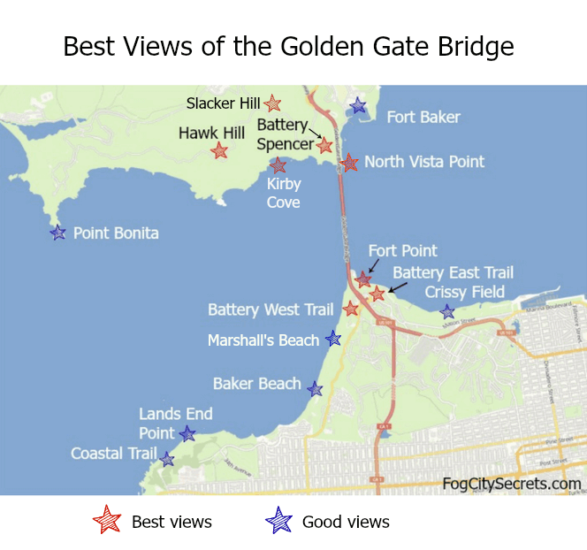
To find all of those places, with info on where they are, where to park, and how to get there by bus, plus photos of the views, see my page on the best Golden Gate Bridge views.
What to See Near the Bridge
Fort Point
Fort Point sits right under the Golden Gate Bridge, built in 1861 to guard the approach to the bay. This Civil War era fort is now a free museum, and an interesting one to visit. Guided tours available, but you can also explore it on your own (when it's open).
This structure was considered historically important when the bridge was being designed so the engineers had to build the bridge around it.
Wander through the rooms and climb the winding stairways to the top. Check out the amazing view from the roof, right under the bridge.
Hours: Fri, Sat, & Sun, 10 - 5.
For more info, see Fort Point.
 Fort Point
There are some great surfing waves that come rolling in right under the bridge near Fort Point. You'll often see surfers out there; pretty daring with the rocks and currents!
Is the bridge haunted? Check out some of the Golden Gate's ghost stories!
More on the Golden Gate Bridge...

Where are the best places to view the bridge and get the best photos?
See Golden Gate Bridge views for how to find all the best spots.

Biking across the bridge is one of the coolest things to do in SF.
Read my tips on renting bikes, doing the ride, taking the ferry back, and what to do in Sausalito, at bike the bridge.

Read about the struggle to build a suspension bridge across the deep and windy channel, at Golden Gate Bridge history.

Wondering where to park at the bridge?
Read my tips on finding free and easy parking, at Golden Gate Bridge parking.
More to explore...


Share this page:
Welcome to San Francisco!
 My son Alex and I, waiting for the Sausalito Ferry
Hi, I'm Karen. I was born just across the Bay, and spent over 30 years in San Francisco, but the City still casts its spell over me.
Here's our guide to SF and beyond, with lots of local tips!
Latest pages...
Explore one of the most charming neighborhoods in SF, Noe Valley. Still "undiscovered" by tourists to the city. My old neighborhood!
Should visitors to SF be concerned about earthquakes? Not really, and here's what you need to know about Bay Area earthquakes.
Admire some great views from a hidden park, Ina Coolbrith Park, on Russian Hill.
See one of San Francisco's best and most-overlooked viewpoints, Grandview Park on Turtle Hill.
Explore my longtime neighborhood, the Sunset District, out by the ocean.
Renting a car at SFO? Handy tips, good things to know.
Is SFMOMA worth a visit? Definitely! It's a fun place to explore, even if you don't like "modern" art.
How to visit San Francisco on a budget. Yes, it can be done!
Stumped for a souvenir? Check out my suggestions for out-of-the-ordinary San Francisco souvenirs.
Climb Telegraph Hill on the Filbert Steps. Hidden gardens and pretty views!
Explore the Lyon Street Steps. Climb the Lyon Street Stairs for great SF views...and a workout.
Local artists paint wonderful San Francisco scenes! See San Francisco art.

Get the latest tips on visiting San Francisco.
SF Bus, BART & Cable Car Routes


Home | Sitemap | Contact Me | About Me
Privacy Policy | Use Policy | Affiliate Disclosure
As an Amazon Associate I earn from qualifying purchases.
FogCitySecrets.com
Inside-Guide-to-San-Francisco-Tourism.com
Copyright© 2009-. All rights reserved.