- Home
- San Francisco Attractions
- Golden Gate Bridge
- Golden Gate Bridge Views
The 17 Best Golden Gate Bridge Views
Here's how to find them...

The Golden Gate Bridge is such a spectacular structure.
I scouted around for the best places to take photos of the bridge, how to get there, and where to park.
What is the absolute best place to see the Golden Gate Bridge? So much competition! But IMO the very best view of the bridge is from the Marin Headlands, from Battery Spencer.
Below you'll find information on how to get to the spots where you can see the best views of the Golden Gate Bridge, with or without a car, and get the best pictures.
Plus all the viewpoints are marked on the maps.
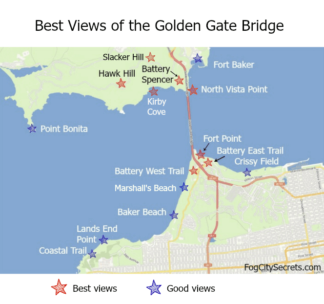
Here's my list of best views of the Golden Gate Bridge:
This is somewhat subjective, of course; the bridge looks great from many vantage points!
Best Views from San Francisco:
- Fort Point
- Battery East Trail (2 spots)
- Battery West Trail
- Golden Gate Overlook
- Crissy Field
- Baker Beach
- Marshall's Beach
- Lands End
- North Vista Point
- Battery Spencer & Conzelman Road Turnouts
- Hawk Hill
- Kirby Cove
- Slacker Hill
- Fort Baker
- Point Bonita
- San Francisco Bay Cruise (sail under the bridge!)
Important: if you park at any of these areas, please leave nothing valuable or visible in the car. San Francisco is suffering from an epidemic of car break-ins: even though the numbers have dropped a lot so far in 2024, it's still high. The thieves target tourist areas and rental cars, so be aware.
Also, these lots are either free or pay-the-machine; any person saying they are collecting parking fees is a scammer.
San Francisco: Golden Gate Bridge Views
The Golden Gate Bridge is visible from all over the city. Just driving around, you'll see it pop up here and there, but some views really stand out.
5 Best Views from San Francisco...
These are some of the views you see in calendars and coffee table books.
- Fort Point
- Battery East Trail (2 spots)
- Battery West Trail
- Golden Gate Overlook

I may earn a small commission if you make a purchase through some of the affiliate links on this page, at no extra cost to you. See disclosure policy. This helps me provide all the free information on the site. Thank you!
Fort Point
Fort Point is the old Civil War fort sitting right under the southern end of the Golden Gate Bridge. The outside areas are now open to the public again.
 Fort Point
There's a road that runs out to the fort, Marine Drive, with two parking areas. You can also ride a bike there from Fisherman's Wharf, or hike down to it from the Welcome Center at the bridge.
The fort itself is quite interesting and worth a visit. It's a museum and you can go up on the roof for another amazing view looking right up at the bridge. Admission is free.
Summer hours: Daily, 10 am to 5 pm.
Winter hours: Friday-Monday, 10 am to 5 pm.
When it's closed, you can still walk around it, but you have to enter it to get up on the roof.
The hours vary as the seasons change; see fort schedule to check.
 Fort Point Inner Courtyard
The little yellow GPS Go Cars have a Fort Point loop option. We did the loop down here; highly recommended. Read our Go Car saga, or to book it, see Go Cars.
Parking: there are two parking lots at Fort Point which provide a good number of spaces. Even if it fills up, people come and go frequently, so you should be able to get a spot there. Parking is free, with no time limits.
Battery East Trail
There are several foot and bicycle paths that run along the east (bay) side of the bridge at different levels.
They offer some great views and make for a pleasant stroll or ride. It's called the Battery East Trail because there are a number of old artillery batteries placed here and there along the paths.
 View from Battery East Trails
You can get to them from the Welcome Center near the bridge (walk down, towards the bay).
Also the Battery East parking lot is in the middle of a couple of the pathways. See map above.
Parking: the Battery East parking lot is convenient and large. Fees are charged between 10 am and 5 pm daily: $1.20 per hour, $7 per day.
 Lower Path Battery East, with Picnic Areas
Bike paths run out to this area from Fisherman's Wharf; it's on the way for cyclists going from Fisherman's Wharf to ride across the bridge and down into Sausalito.
There are no bike rentals at the bridge, but you can rent bikes at a number of rental locations in the Fisherman's Wharf area and on Lombard Street; see my tips on bike rentals.
Battery West Trail
On the western side of the bridge there are some great views along the paths that run along the cliffs.
The remains of the old artillery batteries that used to protect the city are scattered along the trail that follows the edge.
 Battery West Trail View
You can walk over here from the Welcome Center (on the east side of the bridge). There are two underpasses for pedestrians and cyclists: one under the Toll Plaza, near the Welcome Center, and another under the very beginning of the bridge north of the Toll Plaza.
Also, some of the best parking opportunities are on this side of the bridge; there is a series of lots along Lincoln Avenue and Merchant Road as you approach the bridge from the west side.
There is a relatively new "official" viewing point, the Golden Gate Overlook, built near the parking lots on Lincoln Avenue, but the views are great all along the cliff edges.
 Golden Gate Overlook
The old batteries are interesting to explore, but be very careful, especially if you have children with you. They aren't maintained and have sudden drop-offs.
4 More Good Views from San Francisco...
Other bridge views aren't as close up and amazing, but they show the bridge in some very pretty settings.
- Crissy Field
- Baker Beach
- Marshall's Beach
- Lands End
Even though these may not be the "best" views, they have a lot to recommend them: different angles, interesting backgrounds, grand vistas, etc.
Crissy Field
From Crissy Field, you get a nice view of the bridge and the Marin Headlands on the northern side.
 Warming Hut and Crissy Field View
At the end of a long, park-like area you'll reach the Warming Hut, a yellow building containing a snack bar and gift shop. Just across from it, there's a long pier that juts far out in to the bay which gives you another great view of the bridge and the city.
 View from the pier.
By Car. Crissy Field has a good-sized parking lot that's free during the week. Take Mason Street (off Marina Blvd.) from the Marina. The parking lot is just past the roundabout at the end of Mason Street. On Saturdays and Sundays you have to pay to park there between 10 am and 5 pm: $1.20 per hour, $7 all day. Pay at the machines; they accept credit cards and coins, no paper money.
Tip: The parking lot is a dead end. On the map, it looks like you can continue onto Marine Blvd (that goes out to Fort Point), but you'll have to back-track along Mason to hook up with Crissy Field Ave to get there.
On Foot or Bike. You can walk here from Fisherman's Wharf (20-30 minutes). Also, you can rent a bike in Fisherman's Wharf and ride down here; it's a nice flat ride, and a popular one, with great views all along the waterfront. See my page on where to rent bikes and how to get some good deals, at biking the Golden Gate Bridge.
Hike up to the bridge. There's a pathway from this area up to the Golden Gate Bridge and Welcome Center. It only takes about ten minutes, but most of it is a long, steep climb up a rustic stairway.
 Walking route to the bridge from lower parking lots.
However, there are some great views along this path (photo below), so it's worth it if you don't minding being a bit winded!
 The fog suddenly vanished, and there it was.
Baker Beach
From Baker Beach, you get an impressive view of the western (ocean) side of the bridge, and the Marin Headlands on the other side.
 Baker Beach (northern end)
Note: the end of Baker Beach closest to the bridge is also the unofficial nude area, but most of the time you won't see any nudes there;-)
Marshall's Beach is where most of the nudes are; that beach is even closer to the bridge, with great views, but it's quite a climb to get down there.
 Baker Beach (southern end)
Baker Beach has 2 free parking lots, and road parking leading in and out. The lots fill up on sunny weekends, so try to get there before noon.
Also, the #29 Muni Bus will take you there (drops you off at Lincoln Blvd. and it's a 5 min walk from there) . You can take the #38 Geary Bus from Union Square, and change to the #29 at 25th Avenue. See Muni Route Map.
For more info, see Baker Beach.
Marshall's Beach
This is the beach closest to the Golden Gate Bridge on the San Francisco side, hence the great view. Marshall's Beach is just north of Baker Beach; it's smaller and more secluded (and also clothing-optional).
 Marshall's Beach
The path to the beach is down a steep trail with lots of stairs, about halfway along the Batteries to Bluffs trail that runs along the cliffs at the entrance to the bay. The trail head is on Lincoln Blvd in the Presidio.
See Marshall's Beach for more info on the beach and how to find it.
Lands End
Lands End is farther away, but the wild landscape is gorgeous, with a spectacular view of the whole entrance to San Francisco Bay.
 Lands End
If you go out to Lands End Point, you will be looking straight at the bridge. The Lands End Coastal Trail makes a very nice walk; about one hour from the Cliff House and the Sutro Baths to the end of the trail.
For more info and photos of the Lands End trail, and how to get there, see Lands End.
Honorable Mention...
There are also nice views of the bridge from Pier 39, Alcatraz and Angel Island.
For a special treat, watch the sun set behind the Golden Gate on the Alcatraz night tour.
Marin County: Golden Gate Bridge Views
Some of the most spectacular views of the bridge are from the other side, in Marin County just across the bridge, and especially from the cliffs of the Marin Headlands lining the entrance to San Francisco Bay.
Good news: some of them are easy to get to without a car.
Best 5 Marin County Bridge Views...
On the other side of the Golden Gate Bridge
Just across the bridge:
- North Vista Point
The Marin Headlands:
- Battery Spencer & Conzelman Road Turnouts
- Hawk Hill
- Kirby Cove
- Slacker Hill
Map of the Best 5 Marin Viewpoints
 Parking areas marked with a P
North Vista Point View
This is the view from the parking lot at Vista Point, the exit just past the northern end of the bridge.
You can get here by walking across the bridge, or by driving, and taking the first exit after the bridge (Vista Point exit).
 Vista Point View
There's a medium sized parking lot at Vista Point. It's free, but has a four hour limit. Closes for some holidays, like the two weeks around Christmas and New Year's. This lot tends to fill up.
Vista Point is also a stop on the Sausalito loop of the Hop On Hop Off buses. Sausalito is included on the 2-day and premium 1-day City Sightseeing bus passes. See Hop On Hop Off bus tours for more info and booking.
Tip: there's another lot, the North Tower lot, just on the other side of the bridge on Conzelman Road. To drive there, pass by the Vista Point exit and take the next one, the Alexander Avenue exit.
After you take the exit, turn left at the first intersection and go under the freeway. Follow the road a short distance and you'll see the parking lot on your left.
From there, there's a walkway that takes you under the bridge to the Vista Point lot. See map above.
This lot is also free, and has no time limit. It can fill up in summer and on beautiful, sunny days, but it's less busy than the Vista Point lot.
The trail up to the best Marin Headlands view starts at this lot, also. See below.
You can also get to Vista Point by riding a bike across the bridge. Plus you'll see more pretty views on the trip down to Sausalito.
See my tips on biking the bridge , exploring Sausalito, and taking the ferry back to SF.
Bridge Views from the Marin Headlands
The route to the view spots in the Headlands is along Conzelman Road. There are a series of three turnouts along the road with very limited parking.
 Lot for Battery Spencer; first Conzelman Road turnout.
Battery Spencer View
This spot has the famous view you'll probably recognize.
 Battery Spencer View
Battery Spencer is a crumbling artillery battery, built in 1897, that sits on the cliffs close to the northern end of the bridge.
Driving to Battery Spencer: after you cross the Golden Gate, take the Alexander Ave exit. Turn left and go under the highway and you'll be on Conzelman Road.
Follow Conzelman up the hill and very soon you'll see the first of the turnouts with small parking areas on the left side.
The first turnout on Conzelman Road is near the path to Battery Spencer.
The second turnout. (2025 Update: this lot is permanently closed for parking.) But you can still walk here for the view from the Battery Spencer lot nearby. The second turnout is a short walk (less than 5 minutes) from the first one.
There are also great views from the second turnout, but it's worth walking out to the battery for that view, too.
 View from second turnout on Conzelman Road.
From the first parking lot, there's a short, mostly level walk (0.14 miles, 0.23 km) to the ruins of the battery.
This is one of the most spectacular views of the bridge because you are very close and looking right down on the north tower.
Another view from the second turnout near Battery Spencer:
 View from second turnout, Conzelman Road
The third turnout is a longer walk from the battery (15 minutes?). The view is decent, but not as good as the first two.
There is a gravel path alongside the road down to the battery, not steep, and separated from the traffic by a guardrail.
 Third turnout on Conzelman Road
All three turnouts have very small parking lots, holding about 8 cars each. Not surprisingly, these lots fill up fast on weekends and nice weekdays.
There is more parking farther long the road at Hawk Hill, but it's quite a hike back to Battery Spencer from there.
Summer Detour
During the high season, approximately May through October, there is a detour to get up to Battery Spencer and the other good lookout points up there.
Conzelman Road, the road that runs along the bluffs, becomes one-way, allowing traffic back towards the freeway only.
You take the same exit, Alexander Road, off Highway 101 North, but when you come to Alexander Road, you go right instead of left.
Fortunately, they have a big, electric sign at the intersection, telling you there's a detour and to turn right to get to the Marin Headlands.
The detour will take you around to the Bunker Road Tunnel (follow the detour signs along the way) which goes under the mountain and takes you to the Headlands the subterranean way.
It's a long tunnel with only one lane, so there's a traffic light that controls the traffic going through the tunnel. It's a five-minute red light.
Coming out of the tunnel, you'll be on Bunker Road. Just past a cluster of buildings, you'll see the turn off to Battery Spencer. Take McCullough Road up to the roundabout at the top.
From there, you have a choice of going left, down to the Conzelman Road viewpoints and Battery Spencer, or right, on to Hawk Hill and beyond. There are signs there to let you know.
 Headlands detour during the busy months
Cool tip: closer to Battery Spencer, they allow parking in the right lane for quite a distance, which massively increases the number of parking spaces available.
The left lane is used for traffic and is one-way down the hill to the freeway.
There are no set dates for when the detour is in effect; it's basically the summer season and the months on either side.
Buses to Battery Spencer
Tip: you can also get to the Battery Spencer view point without a car. The Sausalito loop of the Hop On Hop Off bus tours stops at the Vista Point on the north end of the bridge.
From there, you can cross under the bridge to the other parking lot and walk up the path to the first Conzelman Road turnout, less than ten minutes and not strenuous.
Note: the 76X route is currently suspended, casualty of Covid. Hopefully it will be reinstated at some point.
On weekends, you can take the Marin Headlands Express 76X. You can catch it at several places in downtown SF and on Union Square (Post and Powell), as well as the toll plaza near the southern end of the bridge, near the Roundhouse Cafe. It stops near the path to Battery Spencer (Kirby Cove Rd stop). See the 76X route and schedule.
 Bus stops and parking lots for Vista Point and Battery Spencer
Also, you can walk across the bridge, then walk up to the Headlands, about an hour and ten minute walk.
There's a small bike rack and some permanent bathrooms near the Battery Spencer lot.
This road is popular with cyclists, but it's very steep and winding, with lots of car traffic. I don't recommend biking up here unless you are very fit and very experienced.
Battery Spencer
The battery itself is kind of interesting to explore, but it's not maintained, so be careful walking around. It was shut down during WW2 and the last guns were removed in 1943.
 Battery Spencer
In its heyday, Battery Spencer had three 12-inch guns protecting the entrance to the bay.
 Battery Spencer
More parking ideas. If you can't find parking in the first three turnouts on Conzelman Road, there are some alternatives.
You might get a spot in the Vista Point lot, but if not, there's a possibility that you can get a place in the lot right by the bridge, on the west side.
The North Tower parking lot is accessed by taking the Alexander Road exit (next one after the Vista Point exit) and heading left under the highway (see map above).
 Route from North Tower lot to Battery Spencer trail.
From there, you can walk up a dirt path to Conzelman Road and on to the Battery Spencer lot. Not a difficult walk and it only takes about 10 minutes.
 Pathway to Conzelman Rd; not as steep as it looks.
From the North Tower lot, you can also check out the view from Vista Point, just on the other side of the road.
There's a walkway that connects the two lots that goes under the bridge.
View from Hawk Hill
Hawk Hill is a bit farther along Conzelman Road, but it's worth a visit.
Not only can you see the bridge, city and bay, you have a 360 degree view of the whole area.
The entrance channel to the bay and Rodeo Beach lie below you, and you can see Mount Tamalpais and the hills of Marin County stretching away.
Looking east, Mount Diablo is visible on a clear day, 30 miles away.
 View from Hawk Hill
The parking lots there hold more cars and the view from the lot is amazing.
But it's even better if you climb up Hawk Hill itself. Not a bad climb, maybe 5 minutes to get up there.
The Marin Headlands 76X bus doesn't come this way, so this spot's not easy to get to without a car.
 View of Rodeo Beach and the Headlands, from Hawk Hill
Not surprisingly, this is a great place to watch for hawks and other raptors; often you'll find serious hawk enthusiasts up there with their scopes.
 Birding at Hawk Hill
P.S. There are a couple of porta potties near the parking lot.
There are two more great view spots that require a bit of a hike from the parking areas, but are well worth it: Kirby Cove and Slacker Hill.
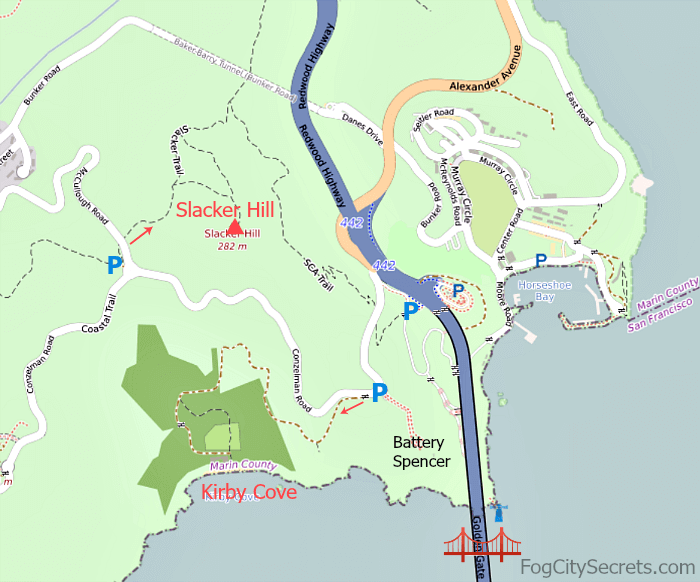
Kirby Cove
Kirby Cove is a small beach west of Battery Spencer, just outside the Golden Gate Bridge with a super view.
The path down to the cove begins a short distance west of the parking lot for Battery Spencer, on Conzelman Road in the Marin Headlands.
The hike is a mile one-way, down a steep, winding trail to the Camp Kirby site. At the beach you'll be looking right up at the bridge. It's quite a climb getting back up, so be prepared!
Near the beach there's a picnic area with picnic tables, BBQ grills and fire pits, plus toilets. The picnic area can be reserved, but is open to the public.
Look for the swing at the beach: a swing with a view of the Golden Gate! But this is one of those Bay Area swings that come and go, like the swing at Billy Goat Hill, so it might not be there. Don't know why they keep getting cut down...grrr.
Camping at Kirby Cove. There is a campground there also with five campsites, but it has to be booked well in advance. Contact (415) 331-1540 for reservations.
Slacker Hill
Slacker Hill sits at the top of the Marin Headlands, with a great, 360-degree view looking down on the bridge and across to the city skyline.
This is a short, steep hike from the parking area just off the roundabout at the intersection of Conzelman Road and McCullough Road. It's 0.4 miles to the viewpoint from the trailhead.
Well worth the effort! But I found it quite strenuous in hot weather. No shade, and nowhere to sit and catch your breath. But I got to see a coyote trotting along the road that crosses the trail.
There's a smallish parking lot (maybe 10 spaces) just off the roundabout, and a restroom. The trail starts right behind the parking lot.
You can also do the more strenuous, 1.6 mile (each way) hike from the North Tower parking lot near the bridge up the SEA Trail to Slacker Hill.
Pick a cool day for this one.
2 More Good Bridge Views in Marin County ...
- Fort Baker
- Point Bonita
Fort Baker View
Fort Baker is just below the northern end of the Golden Gate Bridge. There's a nice view from here as well, plus pretty easy, and free, parking.
It's similar to the Vista Point view, just a little farther away and at a different angle.
 Fort Baker and Angel Island
Besides the view, Fort Baker (not an army fort anymore) houses the popular Bay Area Discovery Museum (bayareadiscoverymuseum.org, fun for kids ages 6 mos. to 8 yrs).
There's also an upscale hotel and restaurant, a nautical bar at the Yacht Club, and a Coast Guard Station.
Take the Alexander Avenue exit off Hwy 101 to get to Fort Baker.
Or rent a bike in SF and ride across the Golden Gate Bridge to Sausalito; Fort Baker is on the bike route to Sausalito.
Point Bonita View
Point Bonita is the rocky spit of land that juts into the entrance to San Francisco Bay.
There is an old lighthouse at Point Bonita that is fun to visit and from that vantage point, you get a sweeping view of the entry to the bay, the bridge and the Headlands.
 View of Point Bonita (at the very end) from Hawk Hill
The lighthouse and tunnel access to the point is only open Saturday, Sunday and Monday, from 12:30 to 3:30 pm.
The trail out there is about 1/2 a mile and is pretty steep in one place, but there's a neat suspension foot bridge to get to the lighthouse.
There are two parking lots for Point Bonita, and the SF Muni Bus 76X goes out there on weekends.
See lighthouse for more info, and Marin Headlands Express 76X for the bus route. The 76X service is temporarily suspended, however.
The bridge is fairly far away from the lighthouse, but it gives an impressive vista of the area.
There's also a colony of harbor seals at the foot of the cliffs that you can see from the trail.
 View along the trail to Point Bonita
Great Views from the Bay
One of the best views of the Golden Gate Bridge is from a boat on one of the bay cruises, especially the ones that take you right under the bridge.
At the Fisherman's Wharf marina on Jefferson Street, you can pick up one of the fishing boats that take visitors out around the bay and under the bridge.
Or take one of the ferries that leave from the wharf from Pier 39 (Blue & Gold cruise) and Pier 41 (Red & White cruise) for an hour on the bay and a trip under the bridge.
See my page on all the best bay cruises for more info.
You can book some of the bay cruises at the wharf, at Piers 39 and 41. You don't need reservations for the basic one-hour bay cruise.
The advantage in advance tickets would be not having to stand in line to get tickets on the day.
There are lots of sailings, usually every hour, or half-hour in high season, and the boats don't fill up.
You can book them online and save $2 at bay cruises.
Parking for the Golden Gate Bridge
Driving to the bridge and looking for parking? Surprisingly, it's easy to park near the bridge, especially on the San Francisco side.
There are nine parking lots at the southern end of the bridge, and some of them are free.
Visit my guide to Golden Gate Bridge parking, with maps, directions, hours and fees for all the parking lots.
Another way to get to all these spots: the Go Cars! They have added a more powerful version to their stable of vehicles and now you can take the Go Car over the bridge, into Sausalito, and up into the Marin Headlands. Even Hawk Hill and Rodeo Beach are on the optional routes!
Plus the regular Go Cars can take you to the viewpoints in the city.
Check out the Go Car tours.
Why was the bridge so hard to build? Read the story of the design and construction of the Golden Gate Bridge at Golden Gate Bridge history.
More great San Francisco view spots...
There are so many pretty views in the city, it's hard to choose just a few.
Here are some of my favorite spots for oohing and aahing:
More to explore...


Share this page:
Welcome to San Francisco!
 My son Alex and I, waiting for the Sausalito Ferry
Hi, I'm Karen. I was born just across the Bay, and spent over 30 years in San Francisco, but the City still casts its spell over me.
Here's our guide to SF and beyond, with lots of local tips!
Latest pages...
Admire some great views from a hidden park, Ina Coolbrith Park, on Russian Hill.
See one of San Francisco's best and most-overlooked viewpoints, Grandview Park on Turtle Hill.
Explore my longtime neighborhood, the Sunset District, out by the ocean.
Renting a car at SFO? Handy tips, good things to know.
Is SFMOMA worth a visit? Definitely! It's a fun place to explore, even if you don't like "modern" art.
How to visit San Francisco on a budget. Yes, it can be done!
Stumped for a souvenir? Check out my suggestions for out-of-the-ordinary San Francisco souvenirs.
Climb Telegraph Hill on the Filbert Steps. Hidden gardens and pretty views!
Explore the Lyon Street Steps. Climb the Lyon Street Stairs for great SF views...and a workout.
Local artists paint wonderful San Francisco scenes! See San Francisco art.

Get the latest tips on visiting San Francisco.
SF Bus, BART & Cable Car Routes


Home | Sitemap | Contact Me | About Me
Privacy Policy | Use Policy | Affiliate Disclosure
As an Amazon Associate I earn from qualifying purchases.
FogCitySecrets.com
Inside-Guide-to-San-Francisco-Tourism.com
Copyright© 2009-. All rights reserved.