- Home
- San Francisco Attractions
- SF Beaches
- Mile Rock Beach
Mile Rock Beach
Tiny, but cool!

Mile Rock Beach is a tiny, secluded beach at the entrance to San Francisco Bay, scene of many shipwrecks, but a pretty detour off the gorgeous Lands End Trail.
Here are my local's tips on visiting Mile Rock Beach: how to get there, when to go, and cool things to see nearby!
Jump to:
- Things to do at Mile Rock Beach?
- Where is Mile Rock Beach?
- How to get to to Mile Rock Beach.
- History of Mile Rock Beach.
- Mile Rocks Lighthouse.
- Worst SF shipwreck.
- Best time to go to Mile Rock Beach.
- Things to see near Mile Rock Beach.
- Mile Rock Beach FAQ
Where is Mile Rock Beach?
Mile Rock Beach is located in the Lands End area of San Francisco, in the far northwest corner of the city limits.
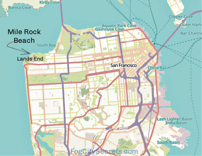
Lands End is a beautiful park area managed by the National Park Service, part of the Golden Gate National Recreation Area, with miles of trails and gorgeous vistas of the ocean and bridge.
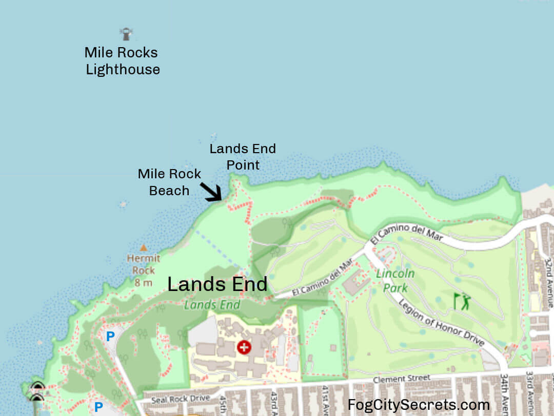
The approach to San Francisco Bay is though a somewhat narrow passageway, with Lands End on one side and the Marin Headlands on the other.
Mile Rock Beach is one of a series of beaches that line the channel leading to San Francisco Bay, including China Beach, Baker Beach, and Marshall's Beach.

How to get to Mile Rock Beach
Mile Rock Beach is one of the detours off the Lands End Trail (aka Coastal Trail). It's only accessible by foot from the trail.
The trail runs from the parking lots near the Sutro Baths at the western end, to a residential area, Sea Cliff, at the eastern end (at 32nd Ave and El Camino del Mar).
The Lands End Trail is 3.4 miles long and the turn off for Mile Rock Beach is about 1.5 miles from the western end.
First you need to get to the Lands End Trail in Lands End.
How to get to Lands End
Here are my tips on how to get to start of the trail near the Cliff House and Sutro Baths.
You can see on the maps where to start, where to park and where to get off the bus. The #38-Geary bus stops right near there, and there are two main parking lots and some other areas to park nearby.
Down the trail to the beach...
If you start near the western end, where most people join the trail, It starts off as a flat, paved walkway, then becomes a dirt path that winds up and down.
About a mile along the trail you'll see the sign for the cut off to go to Eagle Point and Mile Rock Beach.
How many steps to Mile Rock Beach? Some say there are over 240 steps to get down to Mile Rock Beach, others say 100. Let's just say there are a lot! I'm not about to count them!
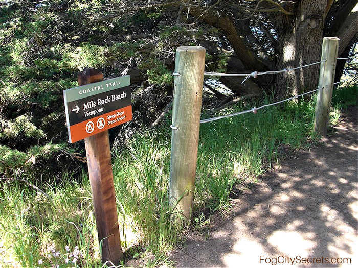
Head down the steep stairs until you come to a split in the trail (it will have a sign for the beach). Go left down more steep stairs and dirt pathways until you get to the beach.
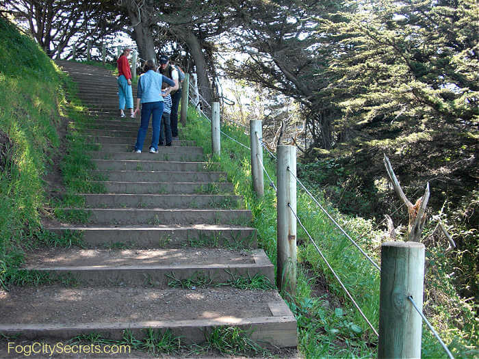 The first steps down from Lands End Trail
After the trail splits, on your way down to the beach, you'll go under a cool arched tree trunk.
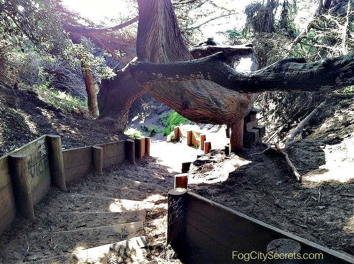 Heading down to the beach
Things to do and see at Mile Rock Beach
- Admire the gorgeous views.
- Do rock art (see the stacks).
- Go up to Lands End Point (more views!)
- Look for whales
- Explore the rest of Lands End's hiking trails
Mile Rock Beach is a very small pocket of a beach, rocky and a bit of a climb to get to. But its location makes it worth a visit: a spectacular panorama right on the channel leading to San Francisco Bay, with a view of the Golden Gate Bridge.
It has a rugged, isolated feel, with big waves crashing on the rocks just off the beach. A perfect spot to sit and contemplate!
Some people engage in the art of stacking rocks there; you'll usually see a number of rock piles delicately balanced here and there.
You can also picnic there, but there are no picnic tables or bathrooms, and no fires are allowed.
From the beach, you can see the cruise ships heading for San Francisco and the huge container ships bound for the Port of Oakland, as well as the sailboats that have ventured out beyond the calmer waters of the bay.
Straight ahead, you can see the former lighthouse in the middle of the channel, Mile Rocks Lighthouse, scene of a tragic shipwreck (see below).
And on the other side of the channel, the range of hills called the Marin Headlands, another great hiking area.
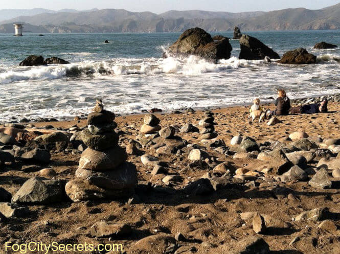 Mile Rock Beach
Hours for visiting Mile Rock Beach:
The beach, along with all of Lands End, is open daily from 6 am to one hour after sunset, per the National Park Service which manages the park.
Mile Rock Beach is open year round.
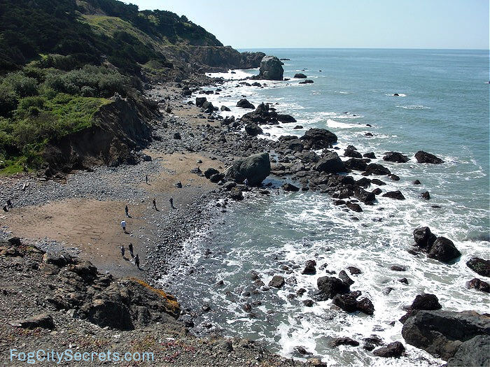 Mile Rock Beach from Lands End Point
Lands End Point
One of the best viewpoints in Lands End is just above Mile Rock Beach, at Lands End Point.
This piece of land juts out into the channel almost as if it were designed for giving people an amazing view of the Golden Gate Bridge! Plus you get a great view of the channel leading to the city and the Marin Headlands on the other side.
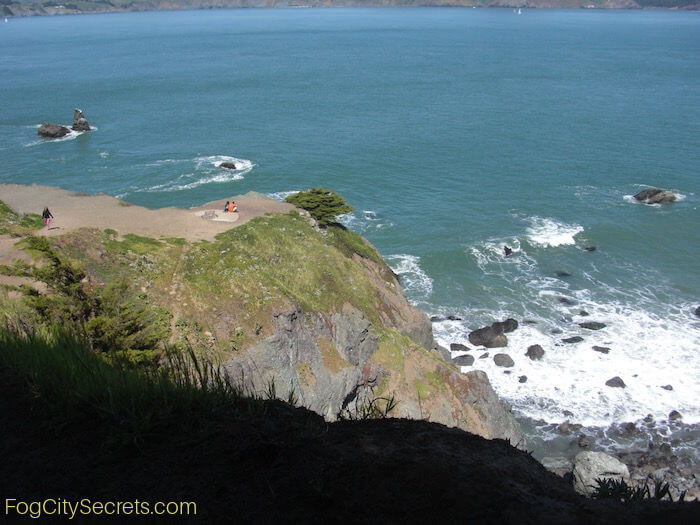 Best view spot at Lands End Point
You can get out to the furthest point above by following the path straight down from the Lands End Trail to the end and climbing down to the lower level on the right (see below).
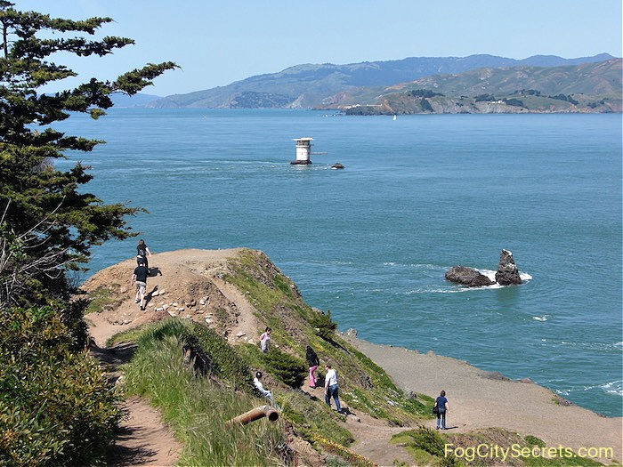 Lands End Point
You can also get there from Mile Rock Beach, which is on the left side of the Point. Head up the dirt path from the beach.
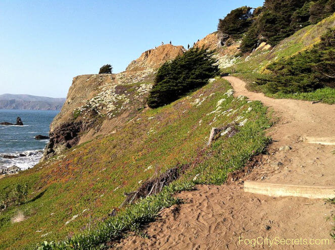 From Mile Rock Beach up to the Lands End view point
Watch for whales
During whale migration seasons you might catch a glimpse of these beautiful creatures in the channel. The numbers vary from year to year; one year I saw a lot of gray whales playing in the water there.
For more info on the whale migration schedule and whale watching tours, see whales in San Francisco.
And of course the sea lions and seals are out and about in the ocean.
The Lands End Labyrinth
Lands End Point was also known for remarkable labyrinth that used to be at the base. Unfortunately, it's no longer there. It was originally built in 2004 by Bay Area artist Eduardo Aguilera and was a popular place to visit for years.
After repeated vandalism incidents, some locals built a heart made of rocks on the same spot, but after that was also destroyed, nothing else was built there. Hopefully, one day the labyrinth will be rebuilt and left untouched so everyone can enjoy it.
History of Mile Rock Beach
The area around Lands End had been a fishing area for the Ohlone Indian tribes that lived nearby, as evidenced by the remains of sea shells and other things discarded by the people residing there.
Later, the area became part of the colonial landholdings of the Spanish settlers, and was eventually taken over by the federal government. It's now part of the Golden Gate National Recreation Area, and managed by the National Parks Service.
The Mile Rocks Lighthouse
The stubbly little remains of the lighthouse just out from Mile Rock Beach has an interesting history.
This approach to San Francisco Bay has been treacherous for ships coming and going from San Francisco for more than a century.
The center of the channel is deep, but there is a shelf of rock that sticks out from Lands End into the passageway for half a mile, just under the surface.
Over 360 ships have gone down while trying to make this trip in or out of San Francisco Bay.
In the 1800's, there were no lights or foghorns. The ships navigated by sight during the day, even using small landmarks like a large white rock on the Lands End Trail (still there) to gauge their location relative to the rocks lying in wait in the channel.
The two rocks called Mile Rocks are visible from Mile Rock Beach (where it got its name) and are the farthest extent of the problematic rock shelf. Because so many ships were being wrecked out there, in 1889 they moored a large buoy out near Mile Rocks. But the current flowing out to sea there was too strong and the buoy was pulled away and they were never able to get one to stay put.
Shipwreck. That was the situation when, one dark, foggy morning in 1901, a passenger ocean liner called the Rio de Janeiro hit the rocks and sank in less than 10 minutes with a huge loss of life. This motivated the city to start work on a lighthouse for that spot.
The Lighthouse is born. On the larger of the two rather small rocks, a group of daring sailors managed to build a tall lighthouse. The rock was only slightly above the water level so was an incredibly difficult place to work with waves crashing over the surface. It was an impressive engineering feat.
Eventually they finished it in 1906 and it provided a strong light as well as a fog horn to warn ships from getting too close. The men who worked out there were pretty isolated because of the difficulty of coming and going by boat.
Because of the expense of maintaining a manned lighthouse out there, in 1966 the lighthouse was reduced to a one story platform with a helicopter landing pad and an automated light.
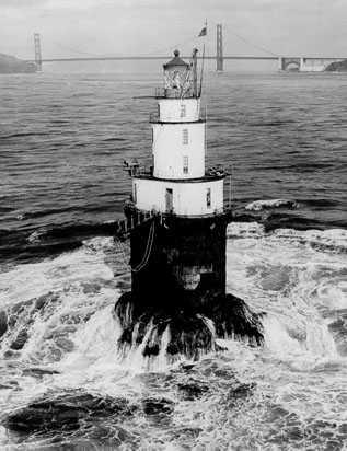 Before 1966
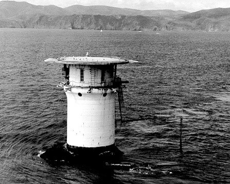 After 1966
You can see how close the base of the building is to the water. It's kind of amazing that it's still attached to the rock after all the pounding of the waves and strong currents since 1906.
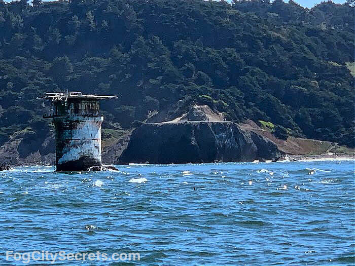 View of Mile Rock Beach and former lighthouse from whale watching tour
For more info on getting out on the water, see my article on San Francisco boat tours.
San Francisco's Worst Shipwreck
The sinking of the steamship SS City of Rio de Janeiro on February 21, 1901, has been called the "Titanic of the Golden Gate".
The ship had started out on a Brazil to U.S. route, then was sold to another company. It was used for troop transport during the Spanish American War, then resumed its service as a passenger liner between Far East and San Francisco.
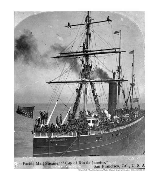 The ship in 1898 with American soldiers
On the date of the shipwreck, the ship's passengers were mainly Chinese and Japanese immigrants bound for San Francisco. The U.S. Consul General for Hong Kong also died in the wreck, along with his wife and two children. The ship had started its voyage in Hong Kong, with stops in Yokohama and Honolulu.
When the ship arrived at the entrance to the bay, the fog was so dense the captain decided to anchor off the Cliff House and spend the night there. Around 5:30 in the morning the fog started to lift, so the captain decided to go ahead and sail into the harbor. But the fog came down again and they didn't see the rocks.
The ship hit the rocks near Fort Point just as it was about to enter the bay, and a huge hole was torn in the hull. The ship sank so fast, only 82 of the 210 people onboard survived. Most of the passengers would have been in their bunks when the ship went down.
Many more would have died in the rough, cold water but were saved by the Italian fisherman, who came out in their boats to pick up the survivors in the water.
The captain and pilot were convicted of gross negligence in making that decision. The captain went down with the ship and his body washed ashore over a year later.
The life boats were never launched, they believe because of a language barrier between the American officers and Chinese crew.
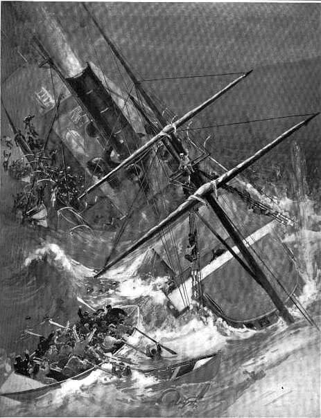 Artist's rendering of the wreck
Frank H. Schell created an illustration (above) of the disaster for a weekly publication shortly after the event.
For a hundred years, the location of the sunken ship was a mystery.
But in 2014, a group using sonar located it in 237 feet of water just outside the Golden Gate, in the deep channel that goes under the bridge.
The Golden Gate Bridge wasn't built until 1937, so it wasn't there when the shipwreck occurred in 1901.
The image below shows the shallow and deeper areas of the channel; you can see the shallow shelf of rocks running from Lands End to Fort Point at the narrowest point of the approach to the bay.
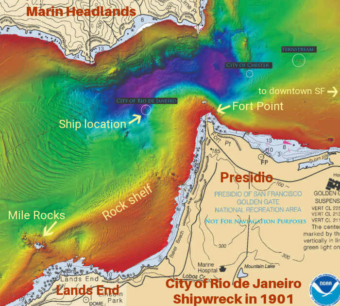 Map of City of Rio de Janeiro Shipwreck
Best time to go to Mile Rock Beach
The best time of the year to explore Lands End and Mile Rock Beach would be in the warmer, dry months, like September and October.
Fog has its charms as well, but doesn't make for the best photos. May, June, and July are the foggy months, especially in the western half of San Francisco.
April and August can go either way, some sunny days and some fog.
The winter months typically alternate rain storms with some sunny days, but it will be chilly. The main problem with winter visits is the mud. The dirt paths can get pretty slippery.
Best time of day to visit Mile Rock Beach? Afternoons tend to be sunnier, though more crowded. You'll have it more to yourself on foggy days or early morning.
Things to see near Mile Rock Beach
This is a beautiful area of San Francisco. You'll be exploring Lands End if you come to see Mile Rock Beach and you'll be treated to gorgeous views of the bay and the Golden Gate Bridge.
This is one of the wilder, more natural areas of San Francisco, with its miles of rustic trails and woodlands. It's hard to believe you're in the city limits of densely populated San Francisco!
Also worth seeing are:
- The Sutro Baths. Strange ruins of a once popular establishment with salt water swimming pools and museum of oddities. All gone now but a spectacular setting at Point Lobos, scene of shipwrecks.
- The Cliff House. Famous San Francisco restaurant with ocean view. There since the 1880's and closed because of Covid. Rumors of another restaurant taking over the space.
- Golden Gate Park. Explore the museums, tea garden, lakes, gardens and more, just a few blocks away.
FAQ for Mile Rock Beach
- Can you swim at Mile Rock Beach? You can, but it would be a really bad idea. There are strong currents along the coast, lots of sharp rocks, and the water is icy cold. Plus there are great white sharks in the water; their hunting ground is the island just off Point Lobos at the entrance to the channel. See more on the dangers of swimming at San Francisco beaches.
- Are there any bathrooms at Mile Rock Beach? No. The closest bathrooms are at either end of the Lands End Trail, quite a hike if you have to go.
- Is this a safe area? In terms of crime, Lands End is one of the safer areas of the city. The park closes an hour after sunset and there is no lighting in the area, so you wouldn't normally be here after dark. The dirt path and steep stairs to get down there would be hazardous in the dark.
- Can you bring your dogs to Mile Rock Beach? Yes, but they must either be on leash or under voice control.
- Is Mile Rock Beach a nude beach? No, it's not. The clothing optional beaches in San Francisco are considered to be Marshall's Beach and Baker Beach.
- How long does it take to walk to Mile Rock Beach? It's about 20-30 minutes along the Lands End Trail from the western parking lots (near the Sutro Baths), then another 10 minutes downhill to the beach.
- Is Mile Rock Beach good for kids? Not really, IMO; at least not younger kids. There's limited sand to run around on and not much space there for games. Too many rocks in the water for wading, plus the strong current and breaking waves mean going in the water is out of the question. Plus it's a long walk down and up for little ones. Lots of rocks to play with, though!
More San Francisco Beaches
For an urban area, San Francisco has a surprising number of beaches.
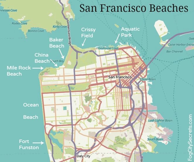
- Ocean Beach. The largest of the SF beaches, stretching 3 miles along the western edge of the city.
- Baker Beach. The postcard view of the Golden Gate. Probably the most popular beach.
- China Beach. Pretty, small beach on the approach to SF Bay.
- Funston Beach. Dog lovers' and hang gliders' beach south of the city limits.
- Marshalls Beach. Closest to the bridge and clothing optional.
- Aquatic Beach. In Fisherman's Wharf. The only safe beach for swimming in San Francisco!
- Crissy Field East Beach. On the bay side of the bridge with great views of the bridge and city.
For more info on all the beaches and maps, see SF beaches.
Super important to know! San Francisco beaches are not swimming beaches.
Why shouldn't you swim at San Francisco beaches? There are very strong currents running past the beaches as well as rip currents that pull swimmers out to sea. Also, the water is extremely cold. The surfers wear wetsuits all year round. See rip currents in SF for more details.
Share this page:
