- Home
- SF Travel Tips
- SF Maps
San Francisco Maps

Here's a collection of San Francisco maps that I've created, covering some popular San Francisco locations.
I've marked various San Francisco attractions and points of interest, plus transportation and parking tips.
Maps created using Open Street Map, under Creative Commons license.
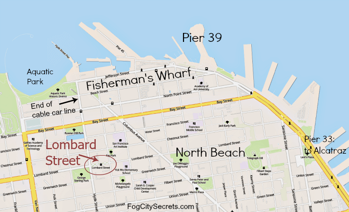
Fisherman's Wharf Maps
Below, the maps show ways of getting to Fisherman's Wharf by public transportation.

The F-Line street cars run all the way down Market Street, then turn left on Embarcadero Street, and travel all the way to Fisherman's Wharf.
Two cable car lines, the Powell-Mason and Powell-Hyde, leave from Powell and Market and end within a couple of blocks of Fisherman's Wharf.
Taking BART? Get off at the Embarcadero Station, then get the F-Line right there and ride it to the Wharf.
The Alcatraz Ferry leaves from Pier 33 (the Bay Street stop, near Pier 35).
For more info, see Fisherman's Wharf.

San Francisco Piers
The Odd-Numbered Piers

The Even-Numbered Piers

See the Guide to the Piers...items of interest located at the San Francisco piers.
Embarcadero Parking

See maps, photos and information about the best parking lots and garages in the Embarcadero area.
Pier 39 Map

Read about the attractions at Pier 39.
San Francisco Beaches

See photos and information and about the San Francisco beaches.
Baker Beach, China Beach & Marshall's Beach

See tips on visiting Baker Beach, China Beach, and Marshall's Beach.
Fort Funston

See photos and information and about Fort Funston.
Golden Gate Park Maps
For everything you've ever wanted to know about the park, see my Golden Gate Park guide.
Eastern Golden Gate Park

Western Golden Gate Park
 Western Golden Gate Park
Bike Rental Locations

Gardens in the Park
See my page on Gardens of Golden Gate Park for more info and photos.


Lakes & Ponds

Dog Parks
 Dog Parks
Lots of fun things to do in Golden Gate Park! Visit the California Academy of Sciences or the de Young Museum, go boating on Stow Lake, or relax in the Japanese Tea Garden.
Explore the Conservatory of Flowers, the Botanical Gardens (Arboretum), play a round of disc golf, or do archery at the range.
Chinatown
 Chinatown Neighborhood
 The alleys of Chinatown
See my Guide to Chinatown, plus more info on shopping, eating, tours and history of the neighborhood.
Lombard Street
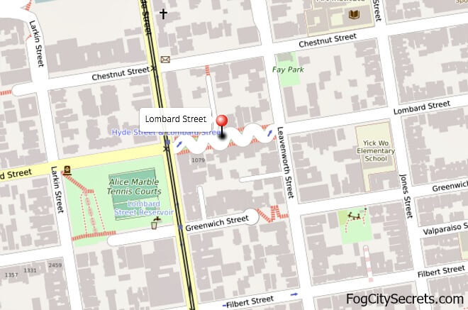 Neighborhood map of crooked Lombard Street
 Best approach to drive down Lombard St.
For info on the history and tips for visiting, see Lombard Street.
Japantown

For things to see and do there, eating, shopping and entertainment, see Japantown.
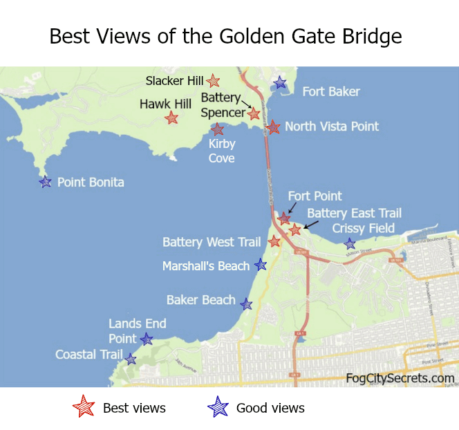
Golden Gate Bridge Maps

Best views of the Golden Gate Bridge
See Golden Gate Bridge views for information on the best places to take pictures of the Golden Gate Bridge: how to find them, how to get there, and where to park.
 Best Views from San Francisco
 Best Views from Marin County
Parking Lots: Golden Gate Bridge
 Parking Lots on SF Side
 Parking Lots on North End of Bridge
For information on each of the parking lots near the bridge, see Golden Gate Bridge parking.
Biking the Golden Gate Bridge
For the series of maps showing the bike route from Fisherman's Wharf to the bridge, see SF bike maps. Below is the bike route from the northern end of the bridge to Sausalito.
 Bike Routes from the Bridge to Sausalito
Red is the newer, less-traffic, route to Sausalito. Blue dots is the older, Alexander Avenue route to Sausalito.
For tips on riding a bike across the Golden Gate Bridge and down into Sausalito, plus maps of the entire route, see biking the bridge.
San Francisco Neighborhoods

Best Areas to Stay in SF
Here are my maps for the best areas to stay in San Francisco.
To find details about each area, and hotel recommendations for each area, see Best Areas to Stay in SF.
Safest areas to stay in SF

 More safe neighborhoods
Best areas for first-time visitors

Lively areas to stay in SF
 For the more adventurous
Blue Angels Views
 Best Location to View the Blue Angels
See tips on watching the Blue Angels, what to do during SF Fleet Week, and going on the ship tours.
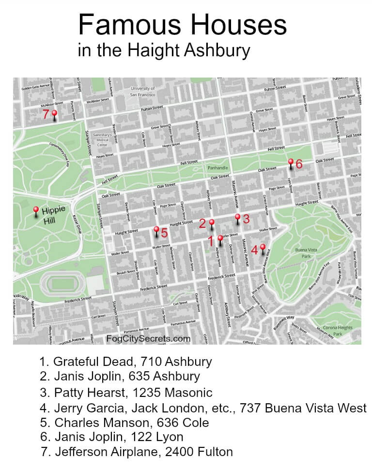
Haight Ashbury
Check out all the things to do and see in the Haight Ashbury neighborhood, including how to find the places where the famous rock-and-rollers lived (plus Charles Manson and Patty Hearst).

Lands End & Legion of Honor
 Coastal Trail Map

See info on the beautiful Lands End Trail, plus the Legion of Honor Museum.
San Francisco Bay Cruises
 SF Ferry Departure Piers & Destinations
Take a boat around the bay and under the Golden Gate Bridge, or maybe to Sausalito. Read about the best bay cruises to take, and where to catch the boats.
Hornblower Cruise Departures

One of the best SF Bay cruises is the Hornblower dinner/dance cruise. See photos and more info on it.
 The Usual Route for the Hornblower Dinner Cruise
Civic Center Restaurants
 Restaurants and Parking in Civic Center
See info on a night out at the San Francisco Opera.
San Francisco Stairways
Coit Tower Stairs
 Filbert Steps and Greenwich Steps
The Lyon Street Steps
 The Lyon Street Steps
Another fun stairway with great views of the Marina and SF Bay: the Lyon Steps.
San Francisco Zoo


Check out the animals at the San Francisco Zoo. Or visit the wild and wonderful Fort Funston beach; walk along the cliffs or climb down to the sandy beach.
Parks and Stairs - Ina Coolbrith, Grandview, Tiled Stairs
 Ina Coolbrith Park in Russian Hill neighborhood
For tips on visiting and photos of the amazing views, see Ina Coolbrith Park.
 Grandview Park in the Sunset District
For more info and images, see Grandview Park and the Sunset District for what to do and see in the neighborhood.
 Locations of the tiled steps near Grandview Park
Two pretty, tiled stairways are right near Grandview Park, in the Sunset District: the 16th Avenue Tiled Stairs and the Hidden Garden Stairs, both worth a visit.
Finding the car rental office at SFO
It's not easy to find the car rental offices at SFO! Here are maps for the car rental locations.
See my page on tips for renting a car at SFO.

The car rental office for the rental car companies is only accessible via the Air Tram system at SFO. And they don't have any signs for the rental car location in the terminal!

Where to catch the shuttle for the Fox and Europcar rental offices from the main rental car office (they're outside the airport-again, no signs).
SF Museum of Modern Art

Best parking for SF MOMA. See more on visiting SF MOMA.
Old San Francisco
 Portsmouth Square in 1846
The very beginnings of San Francisco, before the Gold Rush in 1849. Portsmouth Square is now the center of Chinatown.
 Bird's Eye View of San Francisco in 1876.
This is an early map of SF, before the bridges were built. The western lands were still sand dunes, but the downtown street grid is visible.
More to explore...


Share this page:
Welcome to San Francisco!
 My son Alex and I, waiting for the Sausalito Ferry
Hi, I'm Karen. I was born just across the Bay, and spent over 30 years in San Francisco, but the City still casts its spell over me.
Here's our guide to SF and beyond, with lots of local tips!
Latest pages...
Explore one of the most charming neighborhoods in SF, Noe Valley. Still "undiscovered" by tourists in the city. My old neighborhood!
Should visitors to SF be concerned about earthquakes? Not really, but here's what you need to know about Bay Area earthquakes.
Admire some great views from a hidden park, Ina Coolbrith Park, on Russian Hill.
See one of San Francisco's best and most-overlooked viewpoints, Grandview Park on Turtle Hill.
Explore my longtime neighborhood, the Sunset District, out by the ocean.
Renting a car at SFO? Handy tips, good things to know.
Is SFMOMA worth a visit? Definitely! It's a fun place to explore, even if you don't like "modern" art.
How to visit San Francisco on a budget. Yes, it can be done!
Stumped for a souvenir? Check out my suggestions for out-of-the-ordinary San Francisco souvenirs.
Climb Telegraph Hill on the Filbert Steps. Hidden gardens and pretty views!
Explore the Lyon Street Steps. Climb the Lyon Street Stairs for great SF views...and a workout.
Local artists paint wonderful San Francisco scenes! See San Francisco art.

Get the latest tips on visiting San Francisco.
SF Bus, BART & Cable Car Routes


Home | Sitemap | Contact Me | About Me
Privacy Policy | Use Policy | Affiliate Disclosure
As an Amazon Associate I earn from qualifying purchases.
FogCitySecrets.com
Inside-Guide-to-San-Francisco-Tourism.com
Copyright© 2009-. All rights reserved.